
Day 113.5: mile 2461.6 - 2471.4
- One for the road
- Open season
After a whopping four hours at Stevens Pass, I was itching to get moving again. But not before appropriately feeding myself. Which, given the limited options at an ski lodge during summer, meant settling for an ice cream cone. With all the huckleberries I have been eating, you would think I would want to try new flavors. Nope. So I walked out of Stevens Pass with a fully loaded pack and a huckleberry flavored waffle cone in hand.

Climbing out of Stevens Pass
The trail was crowded with day and section hikers, but the most noticeable person was an orange-clad hunter wielding a rifle. I proceeded to stop and wrap the orange construction vest (that was in the Stevens Pass resupply box at the suggestion of my parents) around my pack, so that hunters wouldn't mistake Gare Bear in his tan outfit for an actual bear or deer. Okay, Mom and Dad were right yet again... And for the ump-teenth time on this trail, I am a total fashion statement! At least the construction vest is a good conversation starter!

View from tonight's dinner table
It was a moderately easy ten miles to Lake Janus, my destination for the evening. There were tents in every site, and I lucked out and picked a neat guy to share a tent site with. A Washington resident out here doing the PCT section from Stevens Pass to Stehekin, so we had plenty to talk about. Even with the initial conversation, our site was quiet before the stars came out. Neither of our rain flys are on, so hopefully we aren't being overly optimistic about the partly cloudy skies...
Day 114: mile 2471.4 - 2497.7
- Alarms, again
- Glacier Peak Wilderness
I finally broke down and set an alarm this morning. Those morning miles are just so much easier... I only(?) hit the snooze four times, but was still on the trail by 6:20, my earliest start in quite a while.
The first climb took us to the top of Grizzly Peak. In a rare occurrence, the PCT actually went over the top of a mountain, as opposed to skirting its side. It was still hazy in the early morning, but you could barely make out Rainier wayyyy in the distance to the south, and Glacier Peak was looming to the north, getting closer and closer.
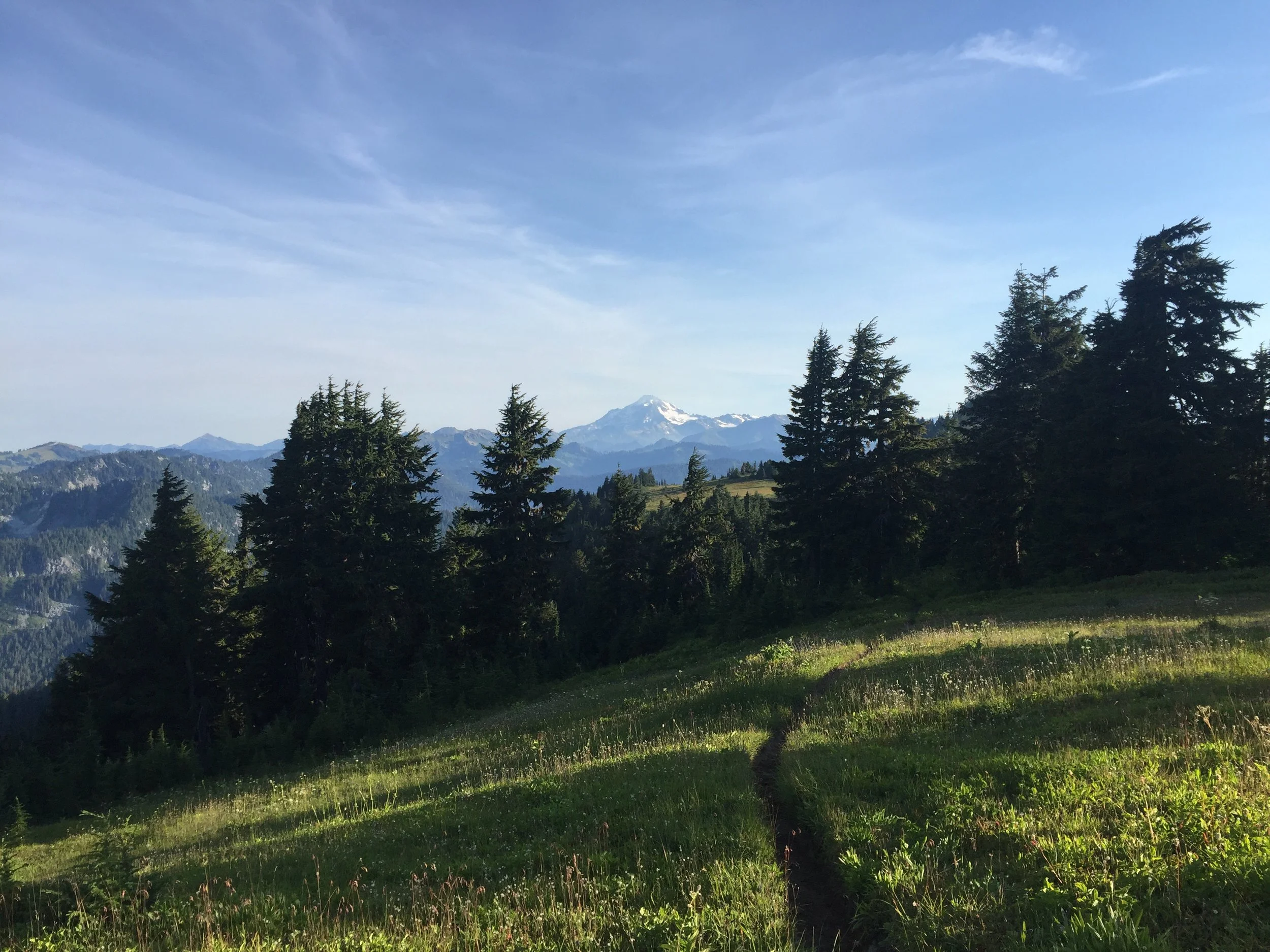
Glacier Peak - getting closer one step at a time
The walking from Stevens Pass has been pretty grand. There hasn't been a whole lot of time spent in the trees, so you get to see a lot of country. Which is absolutely breathtaking. I'm struggling to come up with a comparison. Mountains stretch in every direction, some green with brush and trees, others rocky, barren, and covered with patches of snow. We are walking more or less along the spine of the mountains, with deep valleys off to the west and east, separated from each other by the impressive mountains mentioned above. And then Glacier Peak, just to the north, just seems like the crown jewel of it all. It's something.

Mountains in the morning...

...early afternoon...

...and late afternoon
The elevation gain is also something, and today it kicked my butt, involving over 7,000' of up and 5,500' of down. I was looking back at my mileages, and the day that I summited Glen and Pinchot Passes in the High Sierra? 5,500' of total up. So we are climbing quite a bit more now than we were in the Sierra. That makes me feel a little better about being wiped out at the end of the day.

We'll be seeing more of those tomorrow
I stopped hiking around 5:30pm - early for me. With two more challenging days ahead (at least 7,000' of elevation gain), I figured it was best to not overdo it (too much). I am camped at Reflection Pond, which, based on the name, I was pretty excited about. Turns out it is a murky pond with a lot of bugs, and pretty mediocre reflections. You win some and lose some...
Day 115: mile 2497.7 - 2526.8
- Hump day
- Into the clouds
- Maxed out elevation gain
I only hit the snooze three times this morning (an improvement from yesterday). I had been doing some math (trying not to lose those skills) and knew that if I want to get to Stehekin (my last resupply point) by midday on Monday, today needs to be big. Like, almost-10,000-feet-of-elevation-gain big. After 7,000 feet wiped me out yesterday, my hopes weren't high. But we were going to see how the body felt as the day went on, and make a trail-time decision.

Mountains as far as the eye can see
The early morning walking was absolutely beautiful. There were clouds to the east, which kept the morning very cool, and hid the sun until around 9am. I got a much clearer view of Rainier, and a closer look of Glacier Peak, before the trail dropped several thousand feet in elevation to play around in some glacier-fed, milky white steams.

Finally getting some rays of light

Glacier Peak, with its crown of clouds
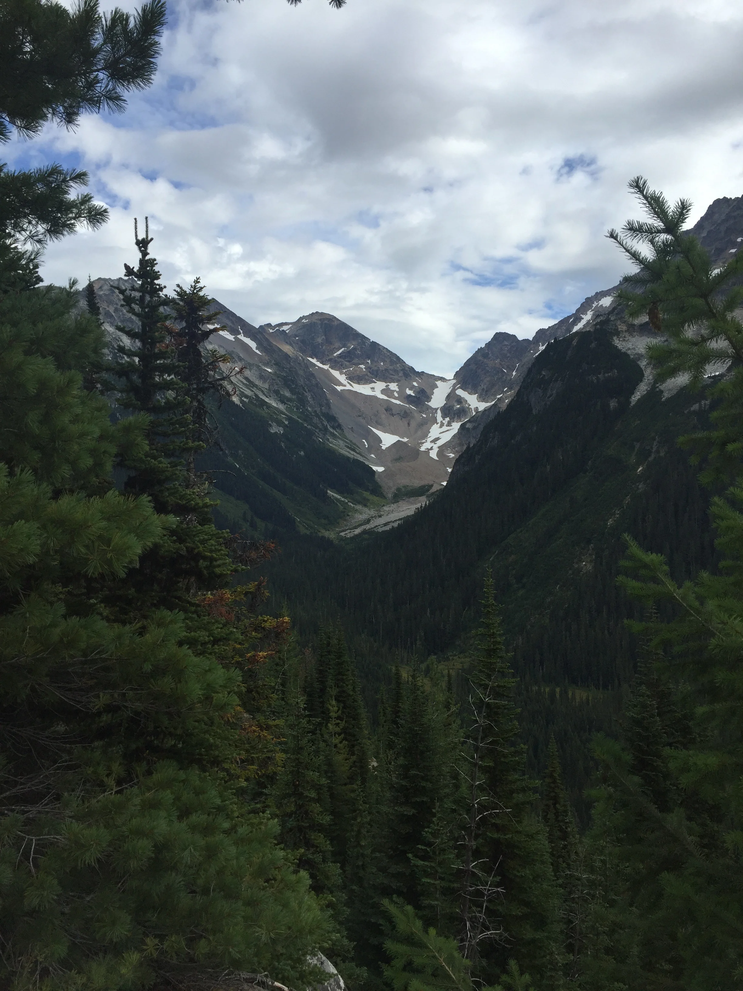
Over the past few days I have passed several southbound hikers, and inquired about trail conditions. "Miserable", "overgrown", "blowdowns", and "slow going" were common descriptors of the trail on the docket for today. Two hikers I passed this morning said their speed was about half of what it normally was because of all the blowdowns. Great...

Interesting choice of bridge construction...
But as I kept walking, these apocalyptic conditions didn't materialize. There were definitely more blowdowns than average, and a few that required some dexterity to get around. But after the obstacle course that was Southern Oregon, this wasn't anything. And the trail was more overgrown than usual, but not enough to drop the pace. It was actually a blessing in disguise, because one of the main overgrown culprits were thimbleberries, which taste pretty damn good, and which I snacked on all afternoon. The one real downside was the clouds, which moved in an obscured what I'm sure were some pretty epic views.

Welp, so much for those views I was bragging about
Walking along this section of trail did make me realize how challenging it has to be to maintain all this. There was one spot where a rockslide had wiped out part of a switchback. And several spots where the trail was cut into a steeeeep hillside. Add the Washington weather, which I hear can be a bit wet and snowy, and the remoteness of the Glacier Peak Wilderness, and it's a miracle this trail is walkable at all.

The trail had a hard time keeping it together
Fortunately the miles came easy today, and I made it as far as I wanted. When all was said and done it was 9,800' of elevation gain, 9,200' of elevation loss, two sore feet, and one hiker happy to set up his tent. I'm camped high on a ridge tonight, so it's probably going to be one of those cold-nosed type of nights, which you won't hear me complain about.

A (deep blue) Mica Lake
Day 116: mile 2526.8 - 2554.5
- Huckleberries aren't the only things that are ripe
- "The Big Grove"
- Drizzling
Turns out hiking all yesterday afternoon in the clouds left me with a poor sense of where I was. I stumbled out of my tent this morning to find the sun rising to what I previously thought was the north, and found Glacier Peak (which I also thought was to the north) looming directly to the south. Not sure how you lose track of a 10,500' peak. I swear I can survive on my own out here... Just need to make it a few more days.

Oh, there's Glacier Peak
Getting dressed this morning was also enlightening. Namely because my sweat-soaked shirt had not dried overnight, and had developed a very special smell. It has been getting more and more pungent as the miles and sweat pile up (and after not doing laundry at my last resupply). Not looking forward to what it will smell like by the time I get to Stehekin tomorrow...
I got going just as light was beginning to touch Glacier Peak, and had a beautiful first half hour above both tree line and the low-lying clouds. Then the trail descended (and kept descending and descending) and it was back into the clouds and trees.

And the sun rising to the "north"

Fog in the valley, clouds above the mountains
Some of those trees were big. Like, really big. While walking along the Suiattle River the trail passed through an area that had never been logged. When I first started hiking, I assumed that these Oregon and Washington forests were the result of nature doing her thing for thousands of years. Come to learn that virtually every acre of timber in these states has been logged at least once. So these "natural" forests? They really aren't that old. And the trees aren't that big. When you see old growth, you know it. And this was an impressive stand of 10-foot-diameter trees whose size was difficult to comprehend. I can't imagine how epic a walk through the woods would be if stands like this were more common.

Sometimes the trees are small...

...and sometimes they are big!
My lunch break consisted of a nap, but not a deliberate one. It was of the I'm-not-sure-how-I-just-fell-asleep variety. I know from experience that this is my body telling me that it is getting worn down. Good thing Stehekin is less than a day away. After lunch it was a slow, gradual, seven mile climb (interrupted as I briefly considered a several-mile side trip to Image Lake, which I hear is absolutely stunning. Then I remembered how badly I stunk. And the nap I just took. Stehekin or bust).
The views from the top were obscured by trees, and the rain that was moving in. I finally got to put my rain gear on in Washington, though the clouds didn't manage anything more than a drizzle for the five downhill miles to camp. Just enough to get the bushes wet on the side of the trail so you get soaked as you brush by. Perfect.
A glimpse through the trees

I'm no expert, but I think the trail goes that way
My shirt still smells god-awful, so it gets to spend the night outside tonight. Maybe it will rain hard enough to wash it! Or maybe a salt-craved deer will come by and munch on it (which has happened to other hikers' clothes before). Or maybe it will just be another normal night...
Day 117: mile 2554.5 - 2574.3
- Cruise Control
- Stehekin
- The Final Countdown
- North Cascades National Park
I woke up to a surprisingly dry and warm morning. The drizzling clouds had passed and it was clear as the stars gave way to the light blue morning sky. It was beautiful, until I had to put that lovely smelling shirt on. The smell must have kept the deer away.
The fifteen miles to Stehekin (or rather, the bus stop to take you to Stehekin) were all downhill, so I put things on cruise control and just walked. Aside from one episode where I tripped over like five rocks and roots in the span of half a mile (and yelled a few expletives to the woods before getting my shit back together) it was uneventful morning walking through trees and along ever-growing rivers.

Impromptu bridge
Stehekin is 11 miles off the PCT, accessible via a dirt road and a bus that runs four times per day. I got on the noon bus, as Animal, MissGuyver, and Doublecheck got off. They told me they are planning to get to the border on Thursday, celebrate, and then take the bus to Vancouver on Friday morning (the only bus from Manning Park to Vancouver leaves at 1:30...). I told them I would catch them and join in the festivities. So it's gonna be one more push to the finish.

Stehekin is a neat little town/resort. Interestingly, it can't be accessed from the outside world by car. Foot, ferry, or float plane are your only options. I ran into Pathfinder, Cheeseburger, Last Call, Heaps, and Zinger - all folks who I had hiked with, and all planning to finish on Thursday as well. Sounds like it is going to be a party at the border.
I showered, did laundry, resupplied (where I found a surprise beverage my parents snuck into the final box), and called my parents using a pay phone and a calling card (the latter of which I had never used before, and didn't know how to use one prior to today. I guess I'm learning about more than just hiking out here).

The last resupply box, with the tastiest snacks packed on top...

...until I dug a little deeper 😊
After a jam packed four hours I caught the last bus out of Stehekin and made it five miles into North Cascades National Park before stopping at one of the established campsites for the night. Cheeseburger and I swapped hunting stories while eating dinner and watching the tame National Park deer walk within spitting distance of our tents. Hopefully I don't wake up with one them trying to get in my tent...
Day 118: mile 2574.3 - 2606.9
- Bears? What bears?
- Changing of the seasons
- Grinding it out
I was on a dimly lit trail by 6:15, after only hitting the snooze a handful of times. The first twenty miles of the day were mainly uphill, albeit at a slow and gradual grade. I saw some super fresh bear tracks walking right down the trail, and thought I may have my first bear encounter. Alas, I never saw the lumbering beasts. When Cheeseburger (who left camp maybe five minutes after I did) caught up to me, he excitedly showed me the pictures of the mom and two cubs he had seen this morning. Hmmm. I'm sure they were in the bushes as I walked by, probably watching me... But I still have yet to see a bear, and my chances are running out.

Glad there was a bridge across this river
I spent some time this morning focusing on the little things that are changing as I get further north. How dawn comes later. How dusk comes earlier. How the arc of the sun gets lower and casts longer shadows. How the morning air has a bit more bite to it. How the leaves have ever so slightly started to turn yellow and brown. And how thru-hikers are charging towards the Canadian border. Fall is settling over the Pacific Northwest. And even in its earliest days, it is beautiful.

Looking back south

Rugged mountains to the northeast
As the day wore on, the climb progressed, and the views got hazy. I don't know where the fire(s) are, but the haze is everywhere. Even with that, we are still hiking some open ridgelines, and getting views of impressively barren peaks. There isn't the verdant green of the mountains from several days ago - it has instead turned to a drier, rockier landscape.

Not as green as it once was
Conversation with Cheeseburger made the rest of the day go quickly despite the mediocre views, and as we closed in on 32 miles I needed the conversation to take the attention off my Achilles and feet. At this point, I'm pushing pretty hard, at a rate that I know isn't sustainable long term. But there is no "long term" anymore. The border is so close. I can almost feel it pulling me up the trail. Canada or bust.

It's the final countdown!
Day 119: mile 2606.9 - 2639.0
- Old faces
- Gettin' wet
- One last grind
I thought it would be easy to get up this morning knowing that it was going to be my last full day on trail. I thought wrong. But like clockwork, that urge to go dig a cathole hit, so I stumbled out of my tent and got the day going.

First light
Things started with a six mile climb, with the trail rising from the wooded valley floor to the open mountain ridge tops. As we climbed above the fog we got some beautiful morning views before the clouds and haze set in for the day. And as usual, the feet were happy while walking the morning miles, which passed quickly.

Trees, fog, and rock

Part of this morning's trail
The past few days we have seen more and more southbound hikers. Some of them are flip-flopping (meaning they started at Mexico heading north and decided to modify their hike by jumping to the Canadian border and finishing the trail heading south) and a few others have finished their hike but are coming back to a U.S. trailhead so they don't have to deal with international travel. As I continue towards the border, I'm seeing more and more faces that I knew were a few days ahead of me. And today, as I was zoning out while walking up a hill, I looked up, and saw Rabbit's smiling face walking down the trail towards me.
After half an hour during which we tried to catch up on everything that had happened in the last 1500 miles (since we had seen each other last) it was time for one last hug and a bittersweet goodbye. I'll be amazed if I make it to the Canadian border without bawling over one thing or another...

Holy sh*t. 35 miles to go

Mountains mountains everywhere
As the afternoon progressed, the weather turned dicier. By the time I was tackling my second to last climb of the day (and the last thousand foot climb of the trail) it was starting to rain. And today, it actually rained. I guess the trail is trying to get a few last jabs in at us before we conquer it.

First hundred and last hundred
Between the rain, the wind, and the feet that were screaming after back-to-back 32-plus mile days, I couldn't have been happier to finally get to camp, change into dry clothes, and get horizontal. I made dinner in my tent (careful not to light the thing on fire), and Cheeseburger and I sat in our respective tents talking over the wind and reminiscing about our adventures until darkness fell.
Despite the milestone, tomorrow still seems like just another day. It still hasn't hit me that things are coming to an end. I'm sure I'll be knocked out by that realization at some point, but right now I'm just enjoying one more night in my tent, listening to the wind and the pitter-patter of the rain.
Day 120: mile 2639.0 - 2658.8
- The end
The clouds never let up, and it was a chilly, wet morning as I went through my final morning routine. Putting wet clothes back on is never fun, but knowing I'd be in Canada in less than four hours provided more than enough motivation. Thoroughly bundled up, we started down the cloudy, wet, windy trail.

One last morning on the trail
The morning had a brief climb, followed by eight miles of easy downhill to the border. We didn't stop, and continued reminiscing about favorite and least favorite parts of the trail. Six miles to go. Then three miles. Then one. Then we rounded a corner, and there was the border, the northern monument, and the official end of our PCT adventure.
I had been playing this moment in my mind since the start of the trail. I never quite figured out how it would go. I didn't know if I would want to laugh or cry. If it would be bitter, or sweet. If it would be rainy or sunny (should have known that one...). As I approached the monument, I wasn't as overwhelmed with emotion as I thought I would be. I smiled, hugged the monument, and stepped back with the smile still on my face. This was it. This was the end.

Canada, oh Canada!

Ta-da!!!
But not "the end". Just "an end". Cheeseburger and I snapped some pictures, had lunch, cracked open the bottle of celebratory whiskey that I had been carrying since Stehekin (and which my trail-angel-of-the-year parents had unexpectedly snuck in my resupply box), finished half the bottle, and proceeded to coast the last eight miles to Manning Park, where it was time to shower, laundry, eat, soak in the hot tub, add "eh?" to the end of every question, and celebrate before catching a 2am Greyhound to Vancouver.

Canadian whiskey seems like an appropriate celebratory beverage
Before getting on the bus, Animal, Pathfinder, MissGuyver, Doublecheck, BFG, Heaps, Cheeseburger, and myself (all having finished today or yesterday) ate, drank, and spent the evening and early morning being merry. It involved stories about the trail, some impromptu hotel lodge duet country karaoke from myself and Animal (that might give a clue as to how many drinks were involved), and fretting that we had missed the bus when it was almost an hour late. It took all of us to make sure no one got left behind, but we and our packs made it on the bus and to Vancouver.

2,658 miles. Zero bears.
And then it was time for people to start going their separate ways. Time to go pursue "what's next". Which not many of us know, myself included. But one thing this trail has taught me is that not having a concrete plan is okay. If I have an overall goal and the intention to achieve it, then I'm not going to fret about the specifics. Things will work out.
I won't soon forget this adventure, or what it has taught me, but there are many things that can't be learned on the trail. And now it's time to go seek out those experiences that can teach me more. It should be a fun ride. Here it goes!