
Day 100: mile 2144.4 - 2154.1
- Bridge of the Gods
- Washington
The Perseid meteor shower peaked last night. Not the most ideal place to view it from while hiking the PCT (an RV park, in a town, at the lowest elevation of the trail), but we still saw some awesome meteors that we couldn't have seen in LA or Seattle. That was the latest I had gone to bed in a long time.
Then 6:30 rolled around this morning, and it was time to get going. A shower, laundry, and two breakfasts were sufficient to wear me out, so I returned to my tent (while it was still in the shade) for a quick nap before handling my resupply. It is almost 150 miles to the next resupply point, so the fully loaded pack is a little on the heavy side. But this might be the heaviest it will be for the rest of the trail. I can live with that.

Necessary? Probably not. Delicious? Absolutely
Then it was lunch (salad and beer) and a giant ice cream cone (which I probably didn't need) before finally getting back on the trail around 3pm. And by "back on the trail", I really mean "on the bridge".

C'mon, the PCT doesn't get its own bridge over this?!?
Fortunately the Columbia River isn't one of the water crossings we have to ford. That would be a pain in the ass. There is a conveniently placed steel bridge (The Bridge of the Gods) that makes our lives easier. Unfortunately they didn't think of hikers (or pedestrians for that matter) when they built the bridge. So it is two lanes of traffic, with no sidewalks. Or shoulder. The lady at the toll booth told us to walk single file towards traffic. So we proceeded the quarter mile across the bridge, garnering the occasional honk (not in a supportive way) and dirty look from drivers. That's when your trekking pole "accidentally" scratches their car... Just kidding. We are still trying to give thru hikers a good name. Even when we get road rage going 3mph.
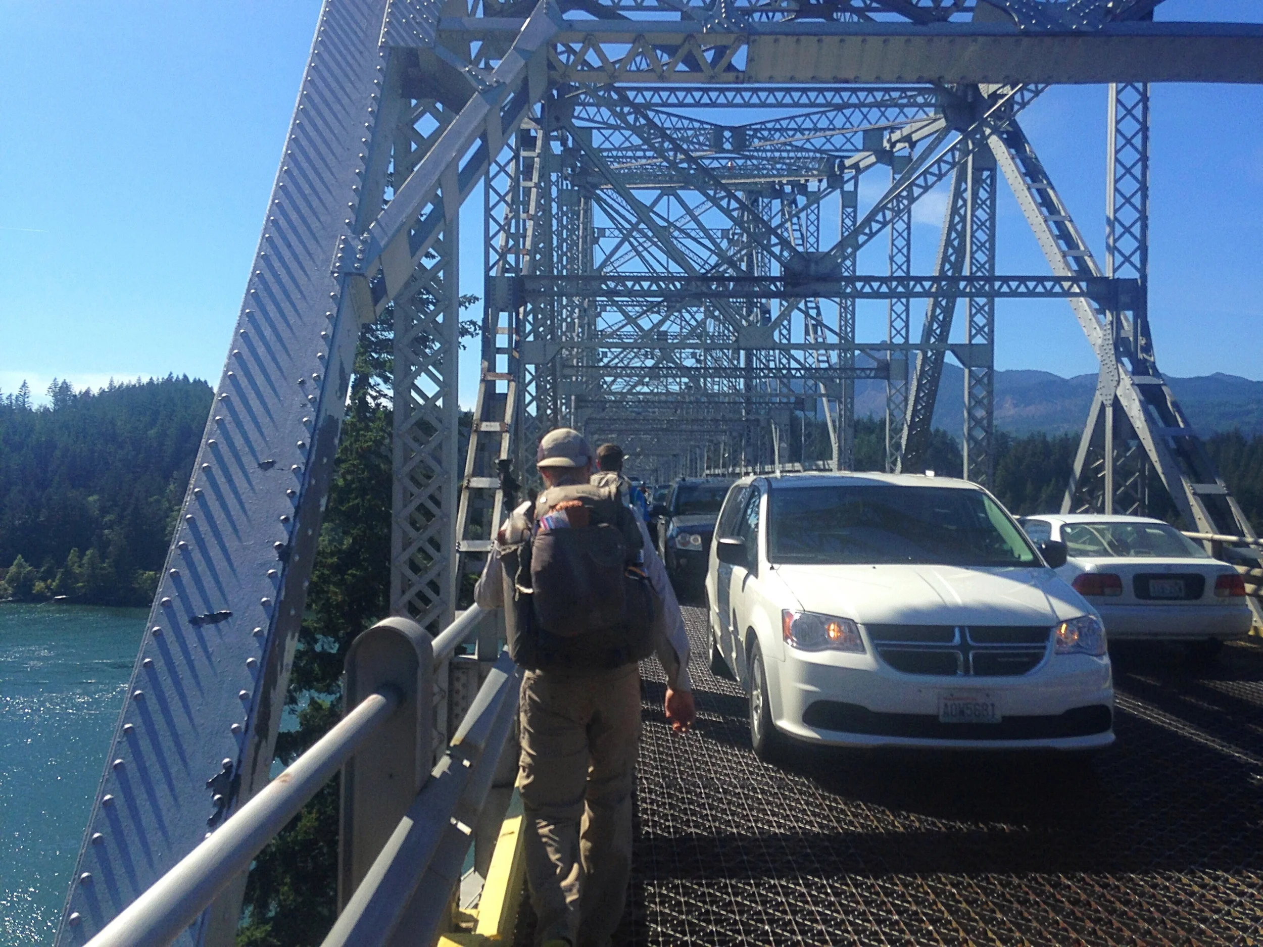
Playing chicken with the cars
The great thing about crossing the Columbia River is that it means we are in our last state. The bad thing is that it is only 140' above sea level. It's tough to get to Canada at that elevation. So the first order of business was to climb back out of this gorge. Which is still in progress, and is just the first of many climbs that we have ahead. Oregon spoiled us with the easy walking and flat terrain. The elevation profile for Washington is a bit more intimidating, with the elevation gain/loss per mile on par with that of the Sierra. But we are going to take things one day, and one step, at a time. And there aren't that many more of those to go.

Numbers keep getting smaller...
Day 101: mile 2154.1 - 2183.2
- Muggy
- Up, down, up, down...
I made it a point to get back on the trail early, as we still had over 1,000' of this first climb left. I camped with Animal and Chance, both of whom I have seen on and off over the past few hundred miles. Animal was right behind me out of camp, and Chance was still out cold. He hikes like a madman though, and will blow by us at some point today, so I didn't feel bad about the early start.
Washington hasn't disappointed with its advertised ups and downs, but there have been fewer views than expected so far. Despite the ups and downs, we haven't spent much time over 4,000' (I think we have actually spent more time below 1,000'). So we got a lot of trees today, with the occasional view of Mt. Hood.

Mt. Hood shrinking in the distance
It was also humid as hell this morning, which I'll blame on the relatively low elevation. Halfway up our second climb of the day and there was not a dry piece of fabric left on my body. Couple the humidity with a dusty trail, and I imagine I look kind of like Pigpen. Hard to believe my clothes were clean less than twenty four hours ago....

More clear-cut area
We also ran into a lot of berries today. I was hiking on and off with Animal, who showed me what huckleberries look like. Not sure if that was a good or bad thing. Stopping and picking/eating them might push my finish date back by a day or so...

Animal walking through the trees
After a dip in one of the creeks, it was another climb to tonight's campsite. We called it an early night, making for a "short" day, but I was okay with that since I'm still nursing the tendinitis in my Achilles (and will be for the rest of the trip). Tendons don't fail me now!
Day 102: mile 2183.2 - 2216.2
- Slimy turds?
- LASH-ers
- The (aptly named) Evergreen State
I felt lazy this morning, as someone hiking by their headlamp came by around 3am, and two more hikers passed by before I had pulled the plug on my air mattress. But sleep felt so good...
I was on the trail by 6:45 (reasonable in my book) and continuing the climb where we left off yesterday. As I was still getting all systems up and running, I stepped over what looked like a green, slimy turd. Gross. Then I turned around to give it a double take (I'm trying to come up with a good reason for giving a turd a double take, but don't have one yet...) and realized it wasn't actually a piece of crap, but was a slug. I guess if you look like something that hikers don't want to step in, maybe the middle of the trail isn't a half-bad spot to hang out.

Corny snail joke of the day: I used to have a racing snail. I took its shell off hoping to make it faster. But it only became more sluggish.
In addition to slugs, we have seen a lot more hikers since Cascade Locks. Many look like thru-hikers, but I don't recognize them. In chatting them up, it seems like at least half of the thru-hiker-looking-esque folks are LASHers, short for Long-Ass Section Hikers. Usually folks who started the trail and skipped a few hundred miles in Northern California, or Oregon, or both. There are also a lot of section hikers hiking the state of Washington. So the remoteness that I was expecting in our third and final state? Haven't found that quite yet. Nor have we come across many views, as The Evergreen State is living up to its name. I hear things open up in the next fifty or so miles...

Mt. Hood, still hanging out back there

Mt. Adams, teasing us through the trees
I have also hiked most of Washington with Animal, a neat guy who has done the Appalachian Trail and recently lost his mom to Alzheimer's. He is out here rocking a purple shirt and hiking to raise awareness and funds for Alzheimer's research. He is blogging as well, so if you are interested in the perspective of the trail from someone other than me, https://hike4mom.wordpress.com is the place to go.
We ended up banging out 33 miles today. Definitely more than I should have done, and the feet were making me aware of that as I stumbled in to camp. I'll be better about limiting the miles tomorrow. I hope 😇

Lunch's dessert (huckleberries)
Day 103: mile 2216.2 - 2247.0
- Mount Adams Wilderness
- Sounds of the "wild"
For the first time on perhaps the entire trail, I was the LAST one out of the campsite. The first person started moving at 4am, at which point I put my earplugs in and fell back asleep. Turns out earplugs + buff pulled down over eyes = sleeping in. I finally hit the trail around 7:15.

Not a spider web you want to walk through...
The first ten miles were easy, and I caught Animal at a road crossing. He was sitting down planning out the mileages for the rest of the trip. At the start of the trip, this seems like a fruitless exercise because there are so many things that can come up. But now, with the end only a few weeks away, we can put together realistic schedules as to when we will finish. And it doesn't seem that far away. Until you realize that every single one of those days you are getting up and walking 25 to 31 miles. One day at a time...
We started walking again, and before long crossed into the Mount Adams Wilderness. Mount Adams has been teasing us through the trees since entering Washington, but now it was time to start up its slopes, with the trail coming only 3.8 miles from the ~12,400' snow and glacier-covered summit. And we finally got some awesome views of Adams, first from a burn on its south side, and later from meadows on its north side. I probably tripped a dozen times as I was gawking at the mountain instead of watching the trail. At least there weren't any cliffs to wander off...

On the slopes of Mt. Adams
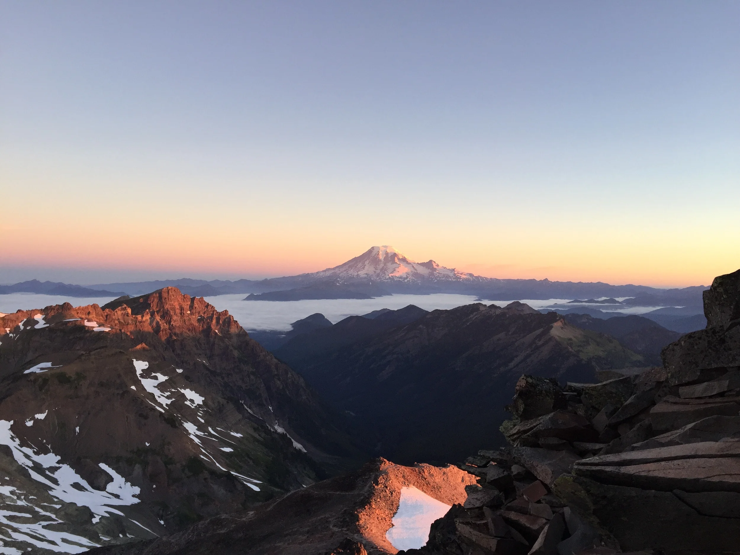
We are also getting within striking distance of Mt. Rainier to the north. It looks absolutely fucking massive (I'm pretty sure that's the technical term). And we are still a few days away. So expect a barrage of pictures as we get closer.

Mount Rainier, getting closer!
In addition to the crunching sounds of our footsteps, hiking through the Mount Adams Wilderness was also accompanied by the constant buzz of planes. Our best guess was that the stream of planes were giving aerial tours of the volcanoes, as a new plane would buzz by every five minutes or so before circling Adams and flying off towards one of the other snow-capped peaks. It would be pretty sweet to see all of this from the air on a clear day like this. But I still think I prefer walking 😊

Not a bad view 😍

Mount Saint Hellens in the hazy distance
Day 104: mile 2247.0 - 2274.3
- Drive-by foraging
- Goat Rocks Wilderness
- Old Snowy
We knew today was going to be a shorter day, but wanted to give ourselves time to enjoy the last five or so miles, which we have heard are some of the best of Washington, and arguably the trail. So it was with only some hesitation that I pulled the plug on my air pad to kick off the day.

Looking back at Adams
The first ten miles were quick, though they could have been much slower if I had stopped every time the trail passed by a loaded huckleberry bush. Instead I worked on my coordination, trying to snag a ripe berry from each bush that I passed without breaking stride. It turned out to be pretty tough to get a ripe berry (without crushing it), especially with my trekking pole alternating hands. But it made the miles pass quicker. And it made them tastier.

Finally above the tree line!

These Dr. Seuss-looking plants were everywhere
We eventually crossed into Goat Rocks Wilderness. I take it the wilderness area got its name from the mountain goat-inhabited peaks, but we didn't see any today. The scenery certainly didn't disappoint. Clear streams, huge green basins, wildflowers, snow-capped peaks, and views of the volcanoes of Washington made for some epic walking. And that was just the start.


Not a bad water source
After winding through another green basin (and taking us up a tough climb), an alternate trail branches off for 0.7 miles. It climbs about halfway up Old Snowy, topping out in a saddle with views of Rainier, Saint Helens, and Adams. Then if you get really ambitious, you can climb/scramble to the top of Old Snowy. Another few tenths of a mile, but hundreds of feet higher, and rewarded with 360-degree views.

Still on the PCT at this point
Animal and I wanted to spend the night on top of Old Snowy, and by 6pm we had summited. We crammed into a small flat spot where we are both cowboy camping, and proceeded to eat dinner while watching the sun set. Words can't describe how beautiful it was. I'll let the pictures do the talking. A great way to cap off my 25th birthday 😊

Tonight's accommodations

Mount Rainier

Mount Adams

Looking east

Early panorama

Late panorama
Day 105: mile 2274.3 - 2292.4
- Starting the day off right
- (butter)Knife's Edge
- White Pass
Turns out the views were spectacular even at night. With the full moon you could see the three volcanoes, and the clouds/fog hanging in the low valleys gave the scene a very calm feeling.
What wasn't calm was how I was woken up this morning. About 4am I heard some rocks sliding around just below our bivy sight. I looked over and saw Animal still in his sleeping bag. Hmmm, that wasn't him. Then I heard a low growl. Oh shit. Not the kind of visitor I wanted. As my mind started going through a thousand different scenarios, I heard a guy whisper "shhh". Then it occurred to me that the sounds were coming from a hiker and his dog, hiking by moonlight to catch a sunrise from the summit. Whew.

Now the sun is in the east
The sunrise rivaled last nights sunset, and the other hiker turned out to be a really neat guy. He had a flask of whiskey to toast the sunrise, and was nice enough to share. It was from a distillery in Bend, and went down way too easily. After he and I passed it back and forth a few times, Animal reminded me that we still had to scramble down off this rock pile, hike down the "Knife's Edge", and then hike 18 miles to town. Given how much of a lightweight I am after so much time on the trail, it's probably good I stopped when I did...

Morning glow over Mount Saint Helens...
...and Mount Rainier
After an incredible sunrise, it was time to pick our way down the mountain to get back to the PCT. Then it was time to cross the Knife's Edge, that intimidating-sounding half-mile of trail, which was actually way overhyped. It was a neat section of trail with great views, but nothing dangerous about it. Shoot. I could have finished that flask of whiskey at the summit.
The remaining miles took us along an exposed ridge (where we saw more than a dozen mountain goats), down through some stream-filled meadows (where we saw some beautiful wildflowers), and then back into the trees (where we saw, you guessed it, a lot of trees). We only stopped to top off our water bottles once, and kept picking up speed as we got closer to town, walking the last two miles in under thirty minutes.

Deep reds

Now I see why they call it Old Snowy

Cruise control
White Pass isn't much of a "town" - just a gas station and a motel across the street from a ski lodge that is closed during the summer. But the gas station accepts resupply packages, and has some fried food and a decent selection of beer, so was a welcome sight after almost 150 miles on the trail since Cascade Locks.

Welcome to White Pass!
Animal and I decided to split a room, and while checking in we noticed a map of the PCT on the wall. It's a common map that is part of a general information brochure about the trail, and I have seen it before. The last time I saw it was in Warner Springs, only 109 miles into our journey. At that point it was slightly overwhelming to see how much further we had to go - best to just not think about it. Now, more than a quarter of the way through our final state, and with only a few weeks left, there is a different feeling when looking at it. But still, it is best to not think about how much we have left...
Laundry, shower, resupply, charging electronics, a call to the parents, eating large quantities of greasy/fried food, and drinking good beer while watching the olympics finished off the day. I can count the number of resupplies left on three fingers... And I'll start walking towards the next one tomorrow.