
Day 30: mile 704.7 - 725.0
- I got a peaceful, easy feeling...
- Napping on the beach
- A country that starts with "W"...
The campground was a good call. With the exception of a car that drove in around hiker midnight, it was a good nights sleep.
I was on a chilly trail by 6am, with my pack and feet feeling muuuch better than last night. The morning was spent walking through the forest, along open green meadows, and through old burn areas. Even though the morning miles went quickly, the scenery was absolutely incredible. There were several times when, coming around a corner or over a pass, I had to stop and stare as a feeling of total peace and awe passed over me. For some reason I had the Eagles lyrics "I've got a peaceful, easy feeling..." playing on repeat in my head, even though I don't know much more of the song.

Many more of these to come

The mountains are interspersed with huge sage flats
After an easy twelve miles I stopped for a break, along with twenty-plus other hikers, at the South Fork of the Kern River. It was a chance to wash my clothes (since we didn't get time in the one washing machine yesterday, eat some lunch, and work on my tan while my clothes dried). Rabbit, Mighty, and Metronome rolled in after a bit, and we proceeded to bask in the sunny warmth, while taking a dip in the creek when things got too warm.

A PCT resort
After two and a half hours and eating way too much food, it was back on the trail for a loooooong climb, followed by a short descent to our planned campsite. As we climbed above 10,000' we could see most of the terrain we had come through that morning, and once we topped out at ~10,400' we could look to the north and see much of the terrain that we'll tackle in the coming days. It was nice to be able to sit and soak in the views. We aren't planning for huge miles in the Sierras, partly due to snow (which we only hit a little bit of today), and partly due to the desire to enjoy some of the best scenery in the world. Today was a great start.

Guess where we are going next?
We got to camp, made dinner, and proceeded to chat and come up with "campfire games". One was to spell each person's first name using the first letter of a country (Garrett might be Guatemala, Australia, Rwanda, etc.) without no repeat countries for the group. Then we got cocky and moved to last names. Zdancewic proved challenging - I'm still trying to think of a country that starts with "W". You don't realize how convenient Google is until you don't have Internet coverage...

More burned area
Day 31: mile 725.0 - 747.2
- Pictures can't do it justice
It was a 6am start this morning, which also happened to be Metronome's fortieth birthday. Not a bad place for someone to welcome in a new decade, even if we weren't able to pack in a cake and candles. Mmmmm, cake...

Magic hour
After averaging over 25 miles per day in the desert portion, it seems like the last two days have been soooo slow, even though we are still knocking out more than 20. Today consisted of an hour-plus break before noon, and then another hour-plus break early in the afternoon. It is nice to take some of these longer breaks to journal, read, socialize, and of course, sleep.

You get some gnarly looking trees up here...
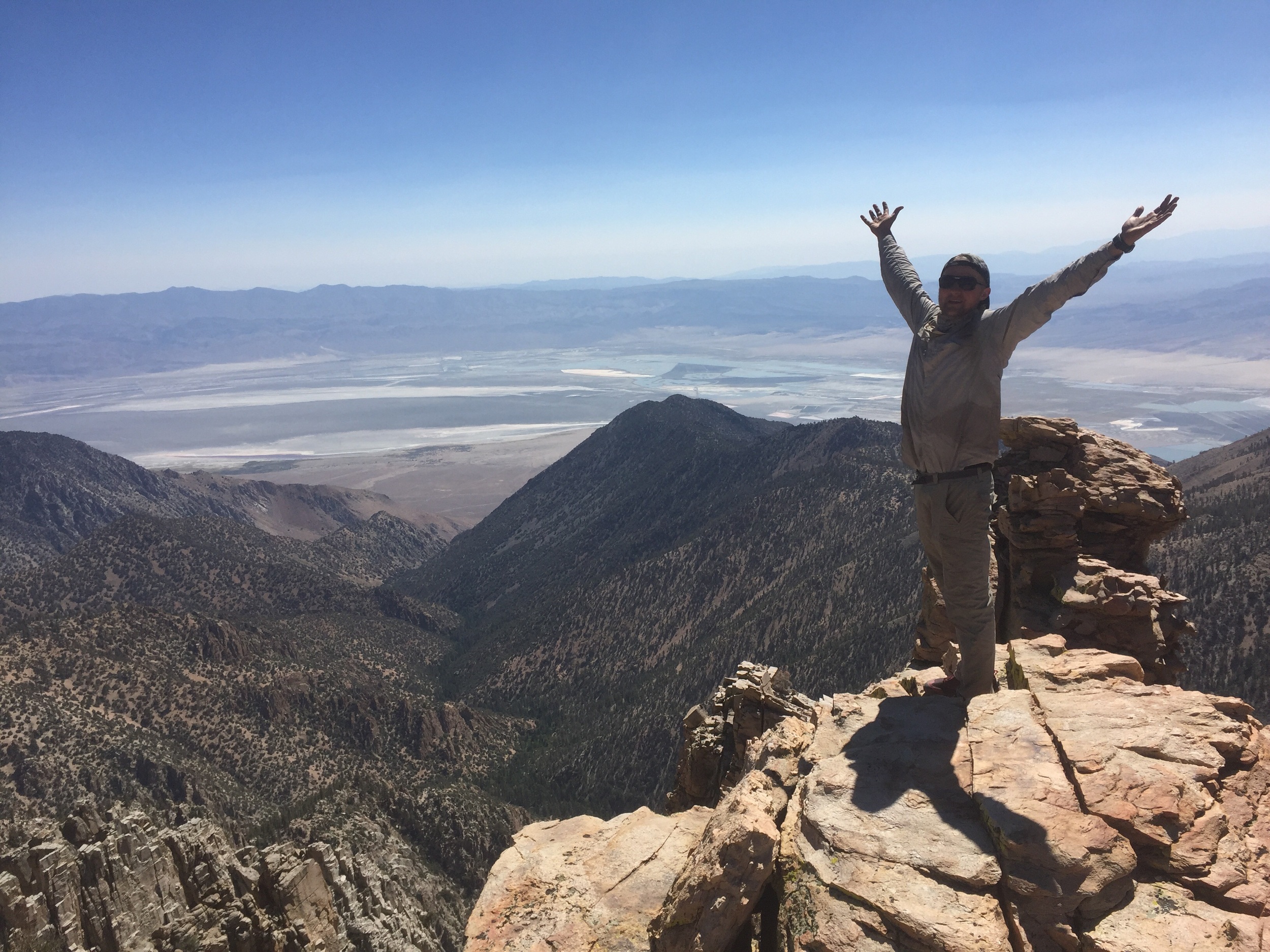
Today's first break coincided with the summit that we spent all morning ascending. The trees did a good job of obstructing the views, but a few rogue rock outcroppings provided the extra forty feet that were needed to earn the view. An easy climb to the top (but a not-so-easy climb down...) and it felt like I was on top of the world. A panoramic picture didn't come close to doing it justice.

Langley and Whitney to the distant north. We'll be there before we know it

The mountains of Sequoia National Park to the west
12,000' Olancha Peak (near last night's campground) to the south, the sage and grass meadows to the west, the snow-capped peaks of Sequoia National Park to the far west, and the 14,000' foot peaks of Mt. Whitney and Mt. Langley to the north were the main eye candy. Then you turned around and got sweeping views of the Owens River Valley, where wayyyyy in the distance you could make out ant-like cars on Highway 395. I could have stayed up there all day 😍
Ta-dah!!!
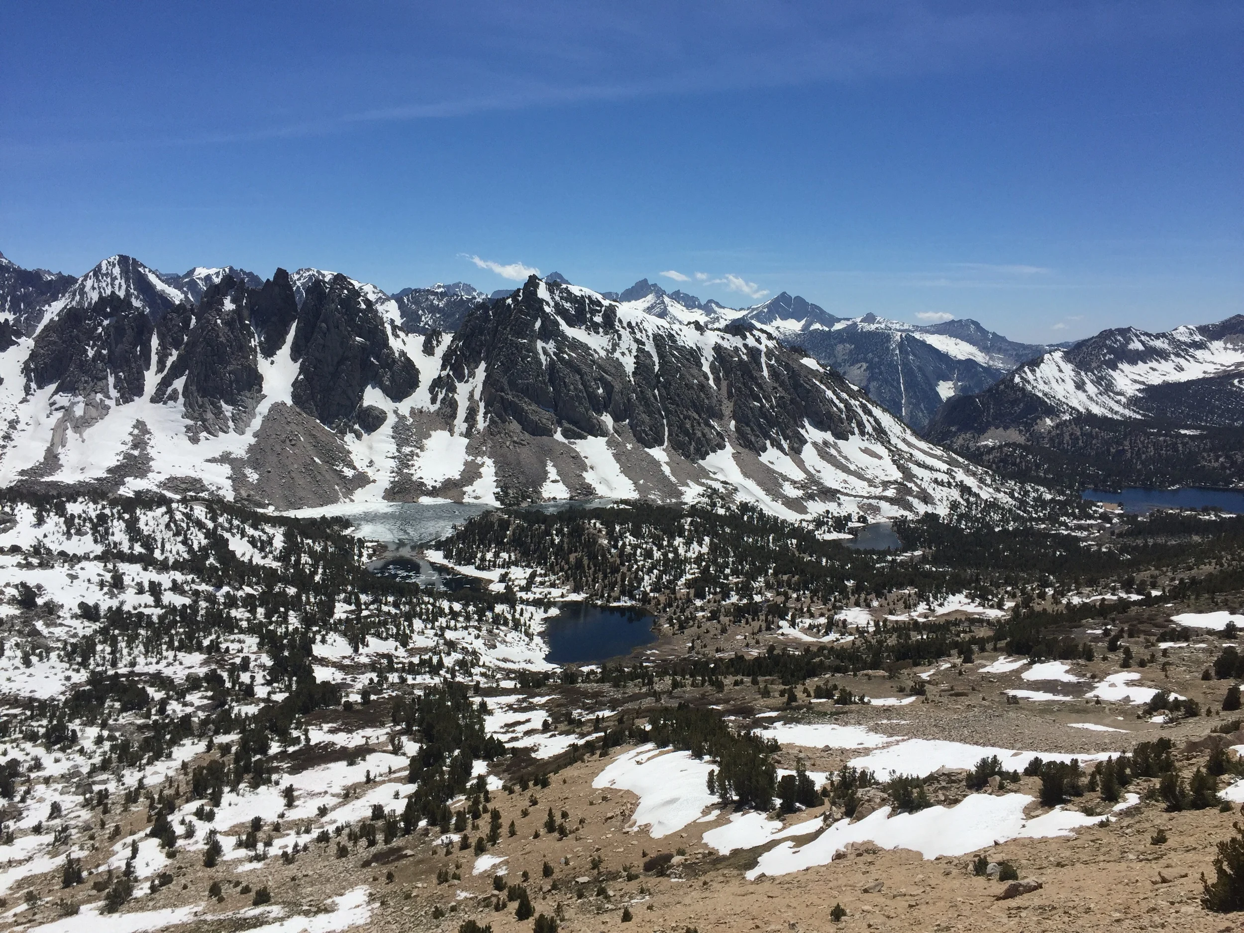
The rest of the day kept us above 10,000', with the day ending at 10,700'. It feels like we just got to the Sierras, and already things are happening fast. We'll attempt to summit Whitney the day after tomorrow, Forrester Pass the day after, and exit over Kearsarge Pass for our resupply the day after. As awesome as the last few days have been, one hiker we spoke with today (who did the trail last year as well) told us that things just get better for the next three days. Let's do it then!

It's sooooo green!
Day 32: mile 747.2 - 766.3 (plus ~1 "side trip" mile)
- Water, water everywhere
- What's today?
- Four-legged critters
Ironically, the coldest night so far has been in the desert mountains of Southern California. Let's hope I didn't just jinx myself... Despite last nights elevation and location in a saddle, I slept warm and well.

Gettin' into some snow

Aaaaaaaand more snow...
I hit the trail as the sun was rising, and made easy miles. Having eaten a good bit of my food, and only needing to carry 1-2L of water in these saturated mountains, my pack feels great.
I was expecting the every water source in the Sierras to be brimming with gorgeous, clear, ice cold, luscious H2O, regardless of where it came from (alpine lake, a spring, or snow melt). I was quick to learn that not all water is created equal, as most sources this far have had a moderately green hue to them, having been drawn from streams/rivers far from the source. That changed today, as I crossed crystal-clear streams coming straight from melting snow drifts, and walked past the heads of a few springs. My lunch break was complemented with an ice-cold washing of my face and hands, and was the perfect pick-me-up for the steep climb set to kick off the afternoon.

Now we're talkin!
As I was trudging up the final climb to Crabtree Meadows, I started thinking about what family and friends might be doing right now. The first step was to figure out what day it was. I was clueless. I guessed Tuesday. Turns out it is Sunday. It's a good feeling to have absolutely no idea what day of the week it is.
The closer I got to Crabtree Meadows, the better the scenery got. Huge open meadows (with more deer than I had seen the last thirty-one days combined), roaring mountain steams (shoes, socks, and pants had to come off to cross a few of these), and tall rocky peaks. Really tall. We are camped 7.6 miles from the summit of the tallest mountain in the continental US. And that mountain is the focus of tomorrow's adventures.

Crabtree Meadows

He/she was posing for me 😎

It's not just the mountains that are impressive

Day 33: mile 767.0 - 772.7 (plus ~16 "side trip" miles)
- On top of the world! (or at least, the continental U.S.)
- The fun way down
- Wright "Creek" fording
A 3:20am wake-up call had our group on the trail by 4, with the aim of summiting Mt. Whitney in the morning, and getting back below the snow fields before postholing conditions set in.
We chose to "slackpack" to the summit and back. Since we were coming back to camp later in the day, we only brought what we would need for the summit trip. This meant leaving behind the tent, sleeping bags/pads, bear canisters, and miscellaneous odds and ends. This is affectionately called slackpacking in the hiker community. Today I didn't mind being called a slacker.

😍😍😍

As beautiful as a sunrise from the summit of Whitney would have been, we didn't feel like starting at midnight, and dealing with ice and switchbacks in the dark. So we settled for a sunrise from just above Guitar Lake, about four miles from the summit. This gave the mountains to our west a brilliant alpine glow that I couldn't quite capture on the camera.
The sun kept rising, and we kept climbing. Eventually we hit a few spots where I was glad to have my microspikes and ice axe - nice to know I'm not carrying those two pounds through the Sierras for nothing! We hit the summit a little after 8am, where we proceeded to take pictures, have a celebratory snack, and text/call our loved ones since this was the first service we had in a week and a half. No one said it, but the cell service is the real reason we all climbed Whitney 😉

Almost there, Rabbit!

I felt like I almost tore my Achilles...


After more than an hour on the summit, it was time to head back down while conditions were good. On the way down Short Shorts (fella we were hiking with) and I had a chance to practice our glissading. Glissading is a fancy term for sliding down a snowy mountain on your butt, ideally using something like an ice axe or a trekking pole to control your direction and speed. Near the bottom of the steepest portion of the climb, there happened to be a huge snow chute which came close to the trail below, and where you could tell folks had glissaded down before.
Turns out glissading is a ton of fun, as long as you don't mind a wet ass for the next half an hour. And it can also be a much quicker, if not drier, way to get off a mountain. Rabbit claims to have videoed it, so maybe I'll share it at some point.
It was back to camp (with only minimal postholing) where we took some power naps before getting back on the PCT to knock out some more miles. I had noticed our maps were using new terms for some of the water sources. "Wright Creek ford" and "Wallace Creek ford" were two landmarks for the day. Those terms didn't sound... inspiring
You know it is going to be fun when you can hear the next "creek" crossing from a half mile away. Aside from some temporarily cold feet, and the extra time to take your shoes/socks/pants off, dry off, and put them back on, these fords haven't been bad yet. I don't envy the folks who are a week behind us and are going to get even more snow melt...

You want me to walk through that?!?
I'm slowly becoming more picky about where I camp, with an emphasis on evening and morning views. This evening I camped with Metronome and Mighty on a big open flat at 11,400'. It's not going to be the warmest night, but with a clear view of Whitney to the east, and the Sierra ridge line to the west, it was too good to pass up. We'll see if I regret this decision in the middle of the night 😁

Dinner and a view

Porcelain throne, PCT/JMT style 😎

Back on the PCT
Day 34: mile 772.7 - 788.5 (plus 7.5 side trip miles)
- High point of the trail. Literally.
- I need a bigger vocabulary
- The Hostel California
I was expecting the wind to hammer my tent last night, but I instead woke up to complete stillness. I'll take it.

Alpine glow
It was a pre-sunrise start as I still had almost 7 miles to get to Forester Pass. At around 13,200', Forester Pass is the highest point on the official PCT. With all the Sierra passes, you generally want to hit them early in the morning before the sun has had a chance to soften the snow. Because as we'll see later, it is tough to make progress when you are postholing.

The trail/creek on the way up

Forester is the low point on the ridge line in the middle

Steeeep faces
One creek ford, and a few thousand feet of elevation gain later, we were staring at Forester. The first half of the switchbacks were still snowed in, so it was up to every hiker to cut their own trail, or follow someone else's footsteps. Rabbit and I have adopts a mantra for these steep or long uphill portions: "just don't stop". So we put our heads down and before long were making the final climb (literally climbing over a cornice) to the pass.

Looking back into Sequoia from Forester

Okay, now someone please help me up
Forester is on the border of Kings Canyon and Sequoia National Parks. So you get great views no matter which way you look. After eating an entire dark chocolate bar (I usually break it up into two or three snacks) and briefly enjoying the views, we headed down while we still had good snow. We made it almost out of the snow fields by the time the postholing started. Those last few hundred yards were slow...

The way down

Postholing: Exhibit A. Good thing there isn't video of me trying to get out of this...
I don't have the vocabulary to do the scenery justice. The snow-capped peaks set against the blue sky, with either an alpine lake, an alpine stream, or a meadow in the foreground just take your breath away.

I watched a rock slide come off those high peaks. Glad I wasn't up there!

I don't think we have to ford this river...
We descended to the bottom of Kings Canyon, then started the climb to Glen Pass. If we thought there was a lot of up and down before, this next section is going to put that to shame, as we have a dozen passes to cross, many over 12,000'.

Starting the climb out of Kings Canyon

Aptly named Bullfrog Lake
But the plan was never to make it to Glen Pass today. Instead we took a trail to the east and exited the Sierras over Kearsarge Pass, bringing us to a trailhead, a ride, and civilization, so that we could get our resupply packages. We ended up getting a ride to Bishop from a day hiker, where we were able to get a handful of bunks at The Hostel California. A shower, laundry, a kitchen, and WiFi await. We will probably be back on the trail tomorrow afternoon, but for now, it's time for some rest and relaxation 😴😴😴

Reminds me a bit of the Canadian Rockies
And the Tetons

With all the mountains I haven't been paying much attention to the flowers

Tonight's accommodations