
Note from the future: I'm still alive! And I found one of the (few?) places that Verizon cell towers can't reach. I'm posting this from mile 1092.3 (South Lake Tahoe) and am taking a few days off the trail and staying with my parents in Reno. I'll be posting a few updates over the next few days (in the order I initially intended). For now, enjoy days 35-40, where I wade through the heart of the Sierra!
Day 35: ~7 "side trip" miles
- Hitching, for reals this time
- Best. Sunset. Ever.
The Hostel California (or, cleverly, THC) was very hiker and climber friendly. When they greet you with a free beer at the front door, you know it is going to be a fun time. Between getting all of our "town chores" (showering, eating, laundry, eating) taken care of, and talking with family and friends, there wasn't a ton of time to get stupid, which is probably for the better.
With our electronics charged and our bodies and clothes as clean as a shower could get them, it was time to get the 40 miles to Independence to pick up our resupply package, then make the last 15 miles to the trailhead. We missed the only bus of the day, so Rabbit and I found a good looking spot along Bishop's main street, and assumed the hitchhiking position (thumbs up, hat/shades off, big smile, hitchhiking sign out).
It took maybe five minutes before a former PCT section hiker pulled over to offer us a lift. He was on his way south for a pretty intense rock climbing trip, and was super friendly. The conversation with Jackalope (his trail name) made for a quick trip. Then it was to the post office to get our packages, followed by the shade of an oak tree in front of the courthouse to play Tetris as we crammed our food into our bear canisters (and ate what didn't fit).

Okay, now how do we get back to this?
Packs fully loaded it was time to figure out how to get the last fifteen miles to the Onion Valley Trailhead. On a weekday afternoon, there weren't many people headed that way. In addition to posting up on the road, we called the local motels/gas stations to see if they knew of anyone who could give us a ride. They did, but we balked at the $60 fee. After about an hour, and only three cars going to the trailhead, Rabbit took a more direct approach by going to the gas station and talking to people passing through. I was manning the sign and the thumb when a gal about my age pulled up to the house we were in front of (turns out it was her parent's house). I asked if she knew anyone who might be able to give us a ride, and despite her three small kids in the backseat, she kindly said that she could. So Rabbit and I squeezed in the front seat, and we made the trip to the trailhead.

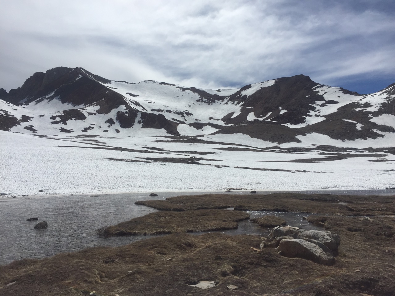
We'll see these mountains up close and personal tomorrow
Then the real work started. It was up and over Kearsarge Pass in the other direction, almost getting back to the PCT before setting camp. As I was pitching my tent the sun and clouds teamed up to put on a magnificent sunset. As in, probably-the-most-amazing-sunset-I-have-ever-seen. I sat on a rock next to my tent, and just drooled (while taking a few pictures). Pics come close to doing this one justice. Not a bad way to start off what should be an amazing section.

Setting the stage...

😍😍😍

#nofilter

Panoramic fire in the sky
Day 36: mile 788.5 - 809.3
- Glen and Pinchot Passes
- Wildlife!!
- "streams"
There are seven more big passes on the JMT portion of the trail. There is also a bunch of advice out there for how to handle snowy passes in the high Sierra, most of which involve trying to perfectly time it late enough so that the snow fields are no longer frozen/icy, but early enough that you don't have slushy postholing conditions (remember how that turns out?). Today I tested those theories.
Glen Pass was only three miles from camp, and after an early start, I topped out just after 8am. It was slooooow going, with an ice-covered, steep approach. I was the first one up there today, with most hikers appearing to wait for those perfect conditions I mentioned above. It was a little slick on the way up, but between the microspikes and a casual pace there wasn't much to worry about. I don't want to go giving my mom too many gray hairs (Hi Mom!!!). The less-than-perfect conditions were worth the solitude on the calm summit. Forester and Whitney almost felt crowded. Not here.

The "trail" up Glen in the rear view mirror

Glen Pass (the more black I wear, the colder t generally is)
Then it was off the other side. There wasn't really a consistent trail all the way off the north side, so I made my own, which included some glissading. This meant dropping 2,000' in elevation reaaaaaal fast. And cold, wet pants. But they were going to get wet anyways.

C'mon, this doesn't make the trail look THAT steep
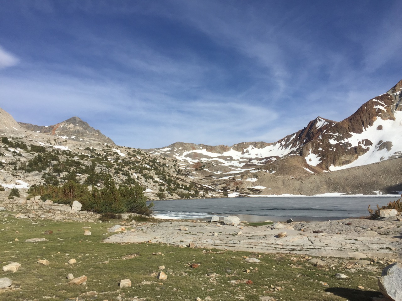
Once the trail dropped below the snow line, it skirted Rae Lakes. This area is a popular hike from the western side of the Sierras, and I ran into four hikers doing the Rae Lakes Loop. They were the first people I had seen on the trail - and it was actually nice to see other people.

Rae Lake reflections

When they decide to build a bridge, they don't mess around...
The four-legged critters were out and about as well. I finally saw something other than a doe, as two groups of bucks were feeding just off the trail. They must be used to people, because they didn't seem terribly worried as I came waltzing by, squeaky pack and all. They were just losing their grey winter coat, and picking up their brilliant red summer coat. I'm still not sure how that makes sense from an evolutionary perspective, because those red coats stick out of the green countryside like a sore thumb.

The Rae Lakes basin
My early afternoon was kind of spent in limbo, as it was looking like I was going to hit Pinchot Pass in the late afternoon. Remember that bit about hitting the passes at the perfect time? 4pm is generally not the perfect time. One option was to throw down camp a few miles from Pinchot, and tackle it tomorrow. That would make for a ~15 mile day today. Another option would be to tackle Pinchot today, and turn around if the conditions were too sloppy. My feet were already soaked from having to ford a "stream" (in Nevada, we call those "rivers") what seemed like every half an hour, so I opted to make a run at the summit.

Feeling that mist on my face made all the fords worth it
The approach to Pinchot Pass
The last few miles before the summit were "open to interpretation" by the hiker. Less than half the trail was visible, and the rest was covered by several feet of snow. So it was a make-your-own-trail sort of afternoon. That meant things went slower, but it hadn't warmed up enough to make postholing a problem, so it was doable. After stopping half a mile from the summit to chain up (put my microspikes on) it was one last push to the top. My feet were soaked, but I bagged my second pass of the day at 4:30pm. Again, I was alone, and again, it felt incredible.

Pinchot Pass (hasn't warmed up much)

Lookin' north from the summit...
The snow, elevation gain, and wet feet from constantly fording streams did a pretty good job of sapping my energy, so I didn't make it far off the other side before I found a flat spot to put my tent. It's a good thing I saw that sunset last night, because I'll be fast asleep by the time it sets tonight.
... lookin' back towards the summit...

... aaaaaaand looking ahead to tomorrow's trail
Day 37: mile 809.3 - 833.3
- Mather Pass
- Leconte Canyon
- The many sounds of water
- Up, down, up, down, up...
Despite sleeping through my alarm, I still hit the trail before sunrise. Cold mornings are still the hardest to get out of my sleeping bag, and spending the night above 11,000' and next to a lake guaranteed a cold morning. At least the wind wasn't blowing.
The early morning called for a river ford (more on that in a bit) but I wanted to keep my feet as dry as possible before that. To that end, the first steam crossing was quite elaborate, involving me throwing my pack across before me, then using my ice axe and a crack in a rock to pull me across this little chasm. Patting myself on the back, I got back on the trail and promptly saw a few deer who weren't scared off during the commotion. As I was watching them (i.e. not paying attention to the trail) I stepped in a puddle that was just deep enough to get my right foot wet. Facepalm... At least I got style points for my crossing.
The river crossing turned out to be easy, thanks to a tree that valiantly decided to fall across the river about 100 yards upstream from the trail. When I get off the trail I have a bone to pick with whoever named these water features, because some "creeks" were almost as big as this "river". In this case, things worked out in my favor.

Do I have cross this?

Nope! Thanks, tree!

Don't forget to turn around and see where you have come from
Then it was up, up, up to Mather Pass. Like yesterday's passes, there was some creativity required to find/make the trail on the way up. I passed two guys who were doing it with NO snow gear. Needless to say, they were going wayyyy slow, and didn't look like they were having much fun. Hooray for having the right tools for the job!

Snow fields for days
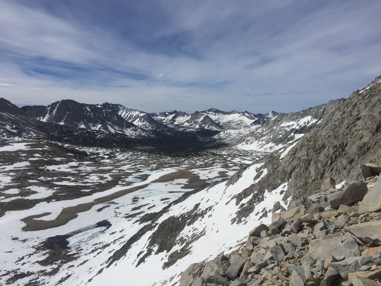
Looking south from Mather Pass

The north side of Mather Pass
After enjoying a victory snack it was off the other side. Ten glorious miles of downhill sliding/hiking until starting the next climb, which brought me into Leconte Canyon. Snow-capped peaks, deep blue lakes, and streams with more water than they were meant to hold filled the afternoon.

Six more glorious miles of downhill
While climbing and descending today, I realized that you can always hear the sound of water. It might be the trickle of the creek you are crossing (or the creek that has decided to run down the middle of the trail). It might be the river roaring next to you, or the waterfall coming down the side of the valley you are in. And if you haven't been careful with your foot placement, there is always the water sopping around in your shoes. And tonight I am camped about twenty feet from one of those roaring rivers. Nothing like some good white noise to fall asleep to 😴😴😴

Leconte Canyon (with requisite water)

Something other than mountains!

Flowers in the canyons
Day 38: mile 833.3 - 857.5
- Muir Pass
- Outrunning a snow storm
- Evolution Basin/Lake/Valley/Meadow/Creek
- You are now leaving Kings Canyon National Park
After getting out of camp as planned, it took three hours to climb the five miles to Muir Pass. It felt like a grind. Not sure if it was because the trail was 99% covered with snow for the last two miles, or because this was the fourth pass in three days, but the legs felt heavy. After one last push (with my arms doing what felt like most of the work), I reached the Muir Hut, signaling the top.

Early morning views

The approach to Muir Pass

Muir Pass, looking south

Looking into Evolution Basin from Muir Pass. Looks chilly
This stone hut (intended for hikers caught in storms during this long exposed stretch of trail) offered a relatively warm, dry place to enjoy a chocolate bar while propping my feet up. Man was it tough to get back on the "trail", knowing that it was really four more miles of make-it-up-as-you-go-along. But the locker room-esque odor in the hut helped make leaving a bit easier.
I was probably the last hiker to leave that hut for a while, because the dark clouds to the south that had been getting darker all morning (it was only 9am) finally started moving north. And dumping their precipitation. I wasn't turning around to take too many pictures, but each time I did the hut and the surrounding peaks were less and less visible.
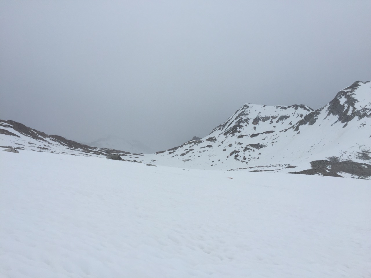
A few minutes ago I could see that mountain on the other side of the pass
I had dropped into the Evolution Basin to about 11,000' by the time the storm started to catch me. It was a light snow, which turned to rain the lower I dropped. As fast as the creeks are running, the last thing they need is more rain...

The first crossing of Evolution Creek
Evolution Basin gave way to Evolution Valley, all the while collecting more and more water. I had heard horror stories of the Evolution Creek ford, and knew that a half-mile alternate existed to cross the creek in a less dangerous spot. I had heard horror stories about the alternate as well, so spent a good chunk of the day worrying about the alternate crossing. Turns out it was a slow-moving, wide river crossing. And since it had been raining for several hours, and would rain for several more, getting wet up to your waist wasn't a big deal.

The second, alternate, crossing of Evolution Creek

The other Evolution Creek crossing. I'm glad there was an alternate...
The rest of the day didn't have the stunning views of the previous week, as the mountaintops were socked in by clouds. I'll have to let my imagination fill in the rest. As I was starting to look for a campsite I passed a sign thanking me for visiting Kings Canyon National Park. It has been fun, and I'm sure I'll be back. But first and foremost, I need to work on drying out my clothes in my tent while it continues to rain outside...

Now you see me, now you don't

Back out of the snow. And a temporary break from the rain
Day 39: mile 857.5 - 874.5 (plus 7.5 "side trip" miles)
- Fresh snow!!
- Little Voice: 1 - Garrett: 0
- Seldon Pass
- Bear "Creek" ford
- VVR or bust
Mother Nature put on an impressive nighttime show of thunder, lightening, and rain. As the rain pelted my tent I started dreading the Bear Creek ford slated for later today. The maps had it listed as a "difficult" ford, the first one to be given this distinction. More water was the last thing it seemed to need...
If there is one thing that will keep me in my tent longer than the cold, it is rain. I turned my alarm off and waited until the pitter-patter stopped. Even without the rain, I started the day wet, as my clothes hadn't dried overnight. The first thing I noticed when stepping out of my tent was the snow that had fallen on the mountaintops. It was beautiful. Then I realized that the trail was taking me to those mountaintops. Looks like I won't be drying out, or warming up, anytime soon.

Snow on the mountaintops!
It was eight miles to Seldon Pass, the lowest pass of the Sierras so far. The four to six inches of fresh snow made up in difficulty what was taken away due to the lower elevation. There were also only a handful of hikers who had summited before me, so tracks to follow were in short supply. Each pair of tracks tried to follow the trail, with varying degrees of success. After falling in a creek (the little voice in the back of my head was like "Garrett, are we sure it's a good idea to cross this creek on this log covered with fresh snow? It might be slippery. Garrett, stop, let's talk this through. GARRETT..." [splash] "I told you so 😏". Maybe I'll listen next time), losing the trail twice, and slipping on the fresh snow more times than I cared to count (ice axe definitely came in handy today), I made it to the summit. I was exhausted, cold, and wet, but the snow capped views were so worth it. Isn't there a saying along the lines of "the greater the challenge, the greater the reward"?

A little bit of fresh snow...

... a little bit more fresh snow...

... aaaand even more fresh snow!

Looking off the north side of Seldon

Threatening clouds and frozen lakes
I was quick to get off the other side, as the Bear Creek ford was looming, and the later in the day I attempted it, the worse it was going to be. As I descended, it started to rain, which helped melt the fresh snow that much quicker. The lower I went, the wetter it got, to the point where the trail had become a creek. Every step seemed to be in ankle-deep water. I was fully expecting to spend the night at Bear Creek, and cross in the morning.
Turns out there were spots where fording was manageable, though you had to go a quarter mile downstream to find one (in a place where the creek split in three, so each one was more manageable).

Bear "Creek"
I still think it is funny that everyone was freaking out about getting to the Sierras too early because "there will be too much snow in the passes". It isn't the snow that there is too much of. It's the damn water. Instead of asking "do you know how to use your ice axe?" people should be asking "do you know how to swim?".
After getting across in one piece I let out a victory cry. It felt great to have this behind me. Not two seconds after the proclamation of my triumph over nature, the first of many roars of thunder shook the mountain. My feeling of victory was short-lived.
Sufficiently humbled, my sights turned to Vermillion Valley Resort (VVR), my next resupply. It was only thirteen miles away, and with the rain, cold, and now lightening, I'll be damned if I was going to spend another night in my wet tent. So I stopped to fill up two liters of water and grab a snack (the irony of filtering water in the pouring rain never gets old), and then it was pedal to the metal for four-plus hours to get to VVR.
The push was worth it. I was about twenty steps behind two hikers when one of the VVR staff pulled up in a van and offered to drive us the last mile. We were all equally soaked, and equally happy to be in a dry spot. Once we got to VVR we learned they only had one more tent cabin available. Not heated, but dry, and with beds and blankets. These two strangers were nice enough to split the room with me, so I didn't have to sleep in my tent!!
Next order of business was food. The little restaurant had just opened, and we snagged a table by the fireplace. Hot cocoa, beer, more hot cocoa, and a hot meal of roasted rosemary chicken and veggies later, we were much more alive hikers. Everything we have (except our sleeping bags) is soaked, but we'll worry about drying things out tomorrow. Now, it's time for a dry bed.
Day 40
- Zeeeerrrroooo!!!
- VVR is the shit
That cabin definitely wasn't warm, but it beat the hell out our wet tents. We woke up to sunshine and clear skies. I'm not sure I have ever appreciated the sun's warming rays so much.

Last night's accommodations
The three of us decided to take a zero at VVR and split one of their actual cabin rooms tonight. The zero consisted of a hot breakfast (eggs, bacon, hash browns, toast), laundry, some time on their agonizingly slow WiFi (the only way to get a message to the outside world), a hot lunch (cheeseburger and fries, with more beer), a shower, planning the next few hundred miles, a hot dinner (tri-tip and more beer), and drinks.
I got along really will with Misguyver and Doublecheck (the two hikers I followed in to VVR yesterday) and Rabbit rolled in this afternoon, making for a fun evening. VVR had a scale which we all used to weigh ourselves, and I came in at 174 pounds. That's down about a dozen pounds from when I started, so I guess it is no longer acceptable to have food leftover when I get to town. I took the scale's reading as an invitation to consume as many calories as I could. Everyone else seems to be of the same mentality.
We are racking up quite the tabs between rooms, meals, and drinks, but given that we just finished arguably the most challenging stretch of the trail (and in non-idea weather) it seems worth it. We'll see how we all feel when we get back on the trail tomorrow...